- by foxnews
- 01 Jun 2026
Explorers discover unknown Antarctic island long marked as 'danger zone' on maps
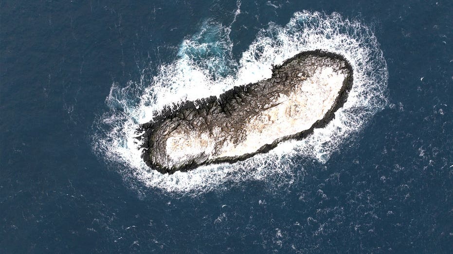
A previously unidentified island in Antarctica's Weddell Sea has been discovered by researchers, after what was marked as a hazard turned out to be rock, not ice.
The discovery was announced in an April press release from the Alfred Wegener Institute (AWI), a German polar research center based in Bremerhaven.
The island is located in the northwestern Weddell Sea, and was spotted during an expedition aboard the AWI's icebreaker Polarstern.
"On our route, the nautical chart showed an area with unexplored dangers to navigation, but it wasn't clear what it was or where the information came from," Simon Dreutter, a bathymetry data engineer at AWI, said in a statement.
After examining the available coastline records, Dreutter looked out the window and saw "an 'iceberg' that looked kind of dirty."
He recalled that "on closer inspection, we realized that it was probably rock."
"We then changed course and headed in that direction, and it became increasingly clear that we had an island in front of us!"
The island is roughly 426 feet long and about 164 feet wide. Officials say it "protrudes about 16 meters (52 feet) out of the water."
Officials are still unclear why the island was marked as a danger zone - noting it resembles surrounding icebergs from an aerial view.
The reason may be tied to the number of uncharted shoals on the seafloor, said a representative from the institute.
The official, who spoke on behalf of the research team, told Fox News Digital the area appears to have "hummocky mounds in which water depths can change abruptly over very short distances."
"Most areas are modeled from satellite data in low resolution," the AWI representative said. "Therefore, many areas, especially inshore and nearshore, can be considered white spots or gaps in the map. In consequence, also nautical charts only have a patchy data coverage."
Since the island has not yet been officially named, it will now go through the formal naming process, with a proposal being submitted to the Scientific Committee on Antarctic Research (SCAR) for consideration.
"But with only about a quarter of the Antarctic water charted, there is still a good scope for discovering landforms on the seabed."
you may also like


- by foxnews
- 01 Jun 2026
Passenger's stunning $5K cash tip leaves cruise worker in tears in shocking video
- by foxnews
- 01 Jun 2026
Construction workers clearing old bombs unexpectedly find 'important' ancient sanctuary


travel
- by foxnews
- descember 09, 2016
Treasure hunters find biggest Viking coin hoard in country's history: 'Without parallel'
Norway's largest Viking coin hoard features 2,970 silver coins minted in England and Germany, reflecting foreign influence on the late Viking economy.
read more